Walk in a nutshell
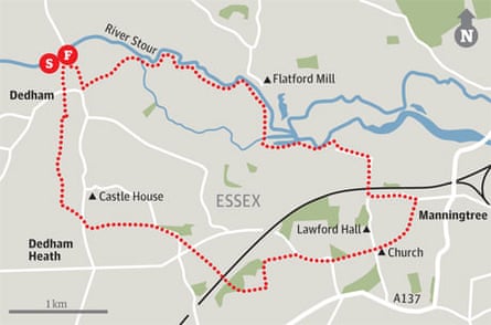
This walk takes you to the heart of "Constable Country" on the Essex-Suffolk border, crossing Dedham Vale and following the river Stour. Starting from the medieval village of Dedham, where the painter John Constable was educated, you take sections of two longer paths, the Essex Way and the St Edmund Way, before coming back along the riverside path that, as a boy, Constable took each morning on his way to school. Dedham Vale is a designated area of outstanding natural beauty and contains some of England's most stunning lowland landscapes, particularly the water meadows of the river Stour.
Why it's special
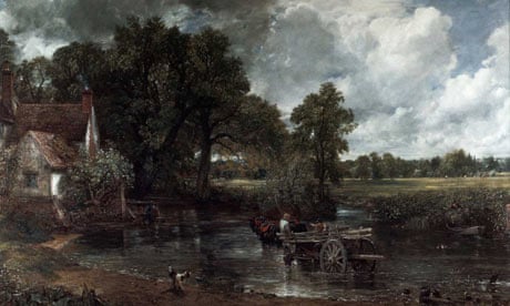
Dedham Vale was Constable's home, and on this walk, you pass many of the scenes he painted. His affection for this area was intense: "I should paint my own places best", he wrote to his friend John Fisher in 1821. "Painting is but another word for feeling." You pass Flatford Mill and Lock, painted by Constable and owned by his father. With a slight detour, you can visit the site where Constable painted the Hay Wain, as well as Valley Farm and a dry dock, which he also immortalised.
Keep your eyes peeled for
The Ascension, by Constable. It is on permanent display in the parish church of St Mary's, Dedham, which dates from the late 15th century.
But bear in mind
The area is shared by grazing cattle, so it is important you keep dogs on a lead.
Recover afterwards
At the Sun Inn on Dedham's High Street, a medieval coaching inn that retains its arch. Enjoy ale and locally sourced produce. thesuninndedham.com
If it's tipping down
The Sir Alfred Munnings Art Museum at Castle House, Dedham, exhibits many paintings by Munnings, a former president of the Royal Academy, in his preserved home and studio. siralfredmunnings.co.uk
How to get there
By car
From London or the M25, take the A12 for Colchester and Ipswich, then turn south on to the B1029. To reach the large, free car park in Dedham from which the walk begins, follow signs at the entrance to the village.
By public transport
It is simplest to begin and end this walk at Manningtree station (at waymark 10). There are good links to London's Liverpool Street station.
Step by step
1. From the car park, walk to the road and turn left. Pass the Marlborough Head Inn, cross straight over at a T-junction and take the footpath opposite.
2. At the end of the sports ground turn right. Halfway along the edge of the field, turn left through the hedge, cross stile, and continue ahead on the Essex Way through three fields into a fourth after a footbridge and stile. Go left.
3. Cross another footbridge and stile and follow the right-hand edge of another field to cross another stile and go through a metal gate, then follow a tarmac drive. Turn right at T-junction, then left just after Hunter's Moon.
4. Go left at The Orchard, then right. Soon cross a stile, climb a bank, then follow the path across a field to a road. Turn right, then left on to Anchor Lane, continuing along a field edge, then go ahead when the view opens up, to pass through a gate at the far side of the field.
5. Cross a footbridge and continue ahead. When you reach a road on a bend, turn right. Follow the road bending right, then signposted footpath left.
6. At the far side of the field, cross a stile and the road. Turn right for 5m, then take a signposted footpath left. Soon cross another stile and follow a signpost, crossing more stiles and the railway line to enter woodland via a footbridge. Follow signposted footpath uphill, then left on a track.
7. Follow the track left then right, past Broom Knolls, then go through a gate and bear right. Continue to a road. Turn right; the road bends left, then sharp right. Soon after, take signposted footpath left through a gate.
8. Look out for a signposted footpath right, through a gate, then bear half-left across a field. Go through another gate, then leave the Essex Way to take a signposted footpath through the left-hand edge of the churchyard.
9. Leave through a small gate beneath a yew tree and follow the narrow path. After some way you can see Felixstowe and the open sea in the distance and the path then bears left and descends to Manningtree station car park. Go left, now on St Edmund Way.
10. When the track bends left, go right under the railway, following another broad track. It takes you left, then right, to join the riverbank via a gate. Turn left.
11. Follow the path, with the river to your right. At a concrete barrier on the right, go through a gate, then bear right with the barrier. Go through another gate, over a concrete bridge, then continue ahead on a raised bank. Just before the bridge over the Stour, turn left on a signposted footpath.
12. Continue for some distance with the river Stour on your immediate right. In due course, go through two gates and over a small concrete footbridge, then head diagonally half-left away from the river, passing under power lines. In the field corner, go through another gate.
13. Follow the path initially between hedges and on in the same general direction, ignoring a signposted path off left and bearing left on a broad track near farm buildings to reach a road. Do not join the road, but turn sharp right on a track.
14. Soon bear left off the track at a signpost, to pass a lake and Dedham Hall. After a small field go through a gate, then in 25m go left over a bridge to re-enter the car park.
Register with Walking World to obtain instructions, OS maps and a downloadable digital mapping file to export into a portable gps system about the walks featured in this series

