FAA INFORMATION EFFECTIVE 18 APRIL 2024
Location
| FAA Identifier: | AND |
| Lat/Long: | 34-29-40.5000N 082-42-33.8000W
34-29.675000N 082-42.563333W
34.4945833,-82.7093889
(estimated) |
| Elevation: | 781.9 ft. / 238.3 m (surveyed) |
| Variation: | 05W (2005) |
| From city: | 3 miles SW of ANDERSON, SC |
| Time zone: | UTC -4 (UTC -5 during Standard Time) |
| Zip code: | 29626 |
Airport Operations
| Airport use: | Open to the public |
| Activation date: | 09/1937 |
| Control tower: | no |
| ARTCC: | ATLANTA CENTER |
| FSS: | ANDERSON FLIGHT SERVICE STATION |
| NOTAMs facility: | AND (NOTAM-D service available) |
| Attendance: | 0730-1930
CALL 864-964-5656 FOR SVC.
ARPT UNATNDD THANKSGIVING, CHRISTMAS, NEW YEARS DAY, AND EASTER. |
| Wind indicator: | lighted |
| Segmented circle: | yes |
| Lights: | ACTVT MALSR RWY 05; HIRL RWY 05/23; PERIMETER LGTS HELIPADS H1 & H2 - CTAF. |
| Beacon: | white-green (lighted land airport)
Operates sunset to sunrise. |
| Landing fee: | yes, NO RAMP FEE FOR PISTON SNGLS. |
Airport Communications
| CTAF: | 123.6 |
| WX ASOS: | 120.675 (864-226-9522) |
| GREER APPROACH: | 118.8 [SUN-FRI 0530-0030 SAT 0530-0000] |
| GREER DEPARTURE: | 118.8 [SUN-FRI 0530-0030 SAT 0530-0000] |
| WX ASOS at CEU (14 nm NW): | 119.275 (864-653-8855) |
| WX AWOS-3 at LQK (19 nm N): | 120.0 (864-843-5801) |
- APCH/DEP SVC PRVDD BY ATLANTA ARTCC ON FREQS 127.5/316.05 (ATHENS RCAG) WHEN APCH CTL CLSD.
Nearby radio navigation aids
| VOR radial/distance | | VOR name | | Freq | | Var |
|---|
| ELWr039/5.9 | | ELECTRIC CITY VORTAC | | 108.60 | | 00E |
| ODFr113/31.5 | | FOOTHILLS VOR/DME | | 113.40 | | 00E |
Airport Services
| Fuel available: | 100LL JET-A
100LL:AFT HRS 100LL FUEL AVBL WITH CREDIT CARD. |
| Parking: | hangars and tiedowns |
| Airframe service: | MAJOR |
| Powerplant service: | MAJOR |
| Bottled oxygen: | LOW |
Runway Information
Runway 5/23
| Dimensions: | 6002 x 149 ft. / 1829 x 45 m |
| Surface: | asphalt/grooved, in good condition |
| Weight bearing capacity: | | PCN 15 /F/C/Y/T | | Single wheel: | 40.0 | | Double wheel: | 58.0 | | Double tandem: | 109.0 |
|
| Runway edge lights: | high intensity |
| RUNWAY 5 | | RUNWAY 23 |
| Latitude: | 34-29.315492N | | 34-30.004100N |
| Longitude: | 082-42.954867W | | 082-42.096843W |
| Elevation: | 751.1 ft. | | 747.1 ft. |
| Traffic pattern: | left | | left |
| Runway heading: | 051 magnetic, 046 true | | 231 magnetic, 226 true |
| Markings: | precision, in good condition | | precision, in good condition |
| Visual slope indicator: | 4-light PAPI on left (3.00 degrees glide path) | | 4-light PAPI on left (3.00 degrees glide path) |
| Approach lights: | MALSR: 1,400 foot medium intensity approach lighting system with runway alignment indicator lights | | |
| Touchdown point: | yes, no lights | | yes, no lights |
| Instrument approach: | ILS/DME | | |
| Obstructions: | 57 ft. trees, 2330 ft. from runway, 800 ft. left of centerline, 37:1 slope to clear | | 38 ft. trees, 1700 ft. from runway, 400 ft. right of centerline, 40:1 slope to clear |
Runway 17/35
| Dimensions: | 4996 x 149 ft. / 1523 x 45 m |
| Surface: | asphalt, in poor condition
WIDESPREAD CRACKS. |
| Weight bearing capacity: | | PCN 6 /F/C/X/T | | Single wheel: | 17.5 | | Double wheel: | 28.0 |
|
| RUNWAY 17 | | RUNWAY 35 |
| Latitude: | 34-30.093065N | | 34-29.294350N |
| Longitude: | 082-42.728498W | | 082-42.486220W |
| Elevation: | 781.9 ft. | | 736.5 ft. |
| Traffic pattern: | left | | left |
| Runway heading: | 171 magnetic, 166 true | | 351 magnetic, 346 true |
| Markings: | nonprecision, in good condition | | nonprecision, in good condition |
| Touchdown point: | yes, no lights | | yes, no lights |
| Obstructions: | 40 ft. trees, 1200 ft. from runway, 100 ft. right of centerline, 25:1 slope to clear | | 60 ft. trees, 1700 ft. from runway, 75 ft. right of centerline, 25:1 slope to clear |
Helipad H1
| Dimensions: | 50 x 50 ft. / 15 x 15 m |
| Surface: | concrete, in good condition |
| Weight bearing capacity: | |
| Runway edge lights: | PERI |
| Traffic pattern: | left | | left |
Helipad H2
| Dimensions: | 50 x 50 ft. / 15 x 15 m |
| Surface: | concrete, in good condition |
| Weight bearing capacity: | |
| Runway edge lights: | PERI |
| Traffic pattern: | left | | left |
Airport Ownership and Management from official FAA records
| Ownership: | Publicly-owned |
| Owner: | COUNTY OF ANDERSON
5805 AIRPORT ROAD
ANDERSON, SC 29626
Phone 864-260-4163 |
| Manager: | BRETT GARRISON
5805 AIRPORT RD.
ANDERSON, SC 29626
Phone 864-260-4163 |
Airport Operational Statistics
| Aircraft based on the field: | | 73 | | Single engine airplanes: | | 56 | | Multi engine airplanes: | | 14 | | Jet airplanes: | | 1 | | Helicopters: | | 2 |
| |  | |
| Aircraft operations: avg 86/day * | | 56% | transient general aviation | | 43% | local general aviation | | 1% | military | | * for 12-month period ending 31 October 2020 | |
Additional Remarks
| - | HELICOPTERS WITH SKIDS ARE RESTRICTED TO LAND ON HELIPADS OR GRASSED AREAS. |
| - | PROFILE OF RY 05/23 RESTRICTS VIS FROM THLD RY 05 TO THLD RY 23. |
| - | WILDLIFE ON & INVOF ARPT; MORE ACTIVE AT DUSK & DAWN. |
| - | AEROBATIC PRACTICE AREA ON & INVOF ARPT |
| - | FOR CD IF UNA TO CTC ON FSS FREQ, CTC GREER APCH AT 864-877-8275, WHEN APCH CLSD CTC ATLANTA ARTCC AT 770-210-7692. |
Instrument Procedures
NOTE: All procedures below are presented as PDF files. If you need a reader for these files, you should download the free Adobe Reader.NOT FOR NAVIGATION. Please procure official charts for flight.
FAA instrument procedures published for use from 18 April 2024 at 0901Z to 16 May 2024 at 0900Z.
IAPs - Instrument Approach Procedures |
|---|
| ILS OR LOC RWY 05 | |
download (288KB) |
| RNAV (GPS) RWY 05 | |
download (293KB) |
| RNAV (GPS) RWY 17 | |
download (272KB) |
| RNAV (GPS) RWY 23 | |
download (290KB) |
| RNAV (GPS) RWY 35 | |
download (273KB) |
| VOR RWY 05 | |
download (306KB) |
| NOTE: Special Alternate Minimums apply | |
download (167KB) |
| NOTE: Special Take-Off Minimums/Departure Procedures apply | |
download (141KB) |
Other nearby airports with instrument procedures:
KCEU - Oconee County Regional Airport (14 nm NW)
KLQK - Pickens County Airport (19 nm N)
KGYH - Donaldson Field Airport (23 nm NE)
18A - Franklin-Hart Airport (23 nm SW)
KEBA - Elbert County Airport-Patz Field (25 nm S)
|
|

Road maps at:
MapQuest
Bing
Google
| Aerial photo |
|---|
WARNING: Photo may not be current or correct
 Photo courtesy of AirNav, LLC
Photo taken 28-May-2012
looking south.
Photo courtesy of AirNav, LLC
Photo taken 28-May-2012
looking south.
Do you have a better or more recent aerial photo of Anderson Regional Airport that you would like to share? If so, please send us your photo.
|
| Sectional chart |
|---|
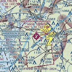
|
| Airport distance calculator |
|---|
|
|
| Sunrise and sunset |
|---|
|
Times for 04-May-2024
| | Local
(UTC-4) | | Zulu
(UTC) |
|---|
| Morning civil twilight | | 06:11 | | 10:11 |
| Sunrise | | 06:38 | | 10:38 |
| Sunset | | 20:17 | | 00:17 |
| Evening civil twilight | | 20:44 | | 00:44 |
|
| Current date and time |
|---|
| Zulu (UTC) | 04-May-2024 15:35:52 |
|---|
| Local (UTC-4) | 04-May-2024 11:35:52 |
|---|
|
| METAR |
|---|
| KAND | 041519Z AUTO 20009KT 3SM +RA BR OVC009 21/19 A3008 RMK AO2 RAB07 CIG 007V011 P0008 T02110189
|
KCEU
13nm NW | 041454Z AUTO 00000KT 10SM OVC012 21/19 A3008 RMK AO2 SLP179 T02060194 52007
|
KLQK
19nm N | 041515Z AUTO 20003KT 10SM SCT009 OVC016 21/20 A3008 RMK AO2 LTG DSNT SE T02100204
|
|
| TAF |
|---|
| KAND | 041400Z 0414/0512 VRB03KT P6SM VCSH OVC050 TEMPO 0414/0418 4SM TSRA BR OVC025CB FM041800 18006KT 6SM -SHRA BR OVC040 TEMPO 0418/0422 4SM TSRA BR OVC025CB FM042200 14005KT 5SM -SHRA BR BKN015 PROB30 0422/0504 3SM -TSRA BR OVC008CB FM050400 11004KT 3SM BR VCSH OVC008
|
|
| NOTAMs |
|---|
NOTAMs are issued by the DoD/FAA and will open in a separate window not controlled by AirNav.
|
|


