US8942897B2 - System and method for determining a location of an unloaded unit of agricultural product and locating a desired unit of agricultural product - Google Patents
System and method for determining a location of an unloaded unit of agricultural product and locating a desired unit of agricultural product Download PDFInfo
- Publication number
- US8942897B2 US8942897B2 US13/845,880 US201313845880A US8942897B2 US 8942897 B2 US8942897 B2 US 8942897B2 US 201313845880 A US201313845880 A US 201313845880A US 8942897 B2 US8942897 B2 US 8942897B2
- Authority
- US
- United States
- Prior art keywords
- agricultural product
- location
- unit
- vehicle
- loading
- Prior art date
- Legal status (The legal status is an assumption and is not a legal conclusion. Google has not performed a legal analysis and makes no representation as to the accuracy of the status listed.)
- Active
Links
Images


Classifications
-
- G—PHYSICS
- G06—COMPUTING; CALCULATING OR COUNTING
- G06Q—INFORMATION AND COMMUNICATION TECHNOLOGY [ICT] SPECIALLY ADAPTED FOR ADMINISTRATIVE, COMMERCIAL, FINANCIAL, MANAGERIAL OR SUPERVISORY PURPOSES; SYSTEMS OR METHODS SPECIALLY ADAPTED FOR ADMINISTRATIVE, COMMERCIAL, FINANCIAL, MANAGERIAL OR SUPERVISORY PURPOSES, NOT OTHERWISE PROVIDED FOR
- G06Q50/00—Systems or methods specially adapted for specific business sectors, e.g. utilities or tourism
- G06Q50/02—Agriculture; Fishing; Mining
-
- A—HUMAN NECESSITIES
- A01—AGRICULTURE; FORESTRY; ANIMAL HUSBANDRY; HUNTING; TRAPPING; FISHING
- A01B—SOIL WORKING IN AGRICULTURE OR FORESTRY; PARTS, DETAILS, OR ACCESSORIES OF AGRICULTURAL MACHINES OR IMPLEMENTS, IN GENERAL
- A01B79/00—Methods for working soil
- A01B79/005—Precision agriculture
-
- A—HUMAN NECESSITIES
- A01—AGRICULTURE; FORESTRY; ANIMAL HUSBANDRY; HUNTING; TRAPPING; FISHING
- A01D—HARVESTING; MOWING
- A01D46/00—Picking of fruits, vegetables, hops, or the like; Devices for shaking trees or shrubs
- A01D46/08—Picking of fruits, vegetables, hops, or the like; Devices for shaking trees or shrubs of cotton
-
- G—PHYSICS
- G01—MEASURING; TESTING
- G01S—RADIO DIRECTION-FINDING; RADIO NAVIGATION; DETERMINING DISTANCE OR VELOCITY BY USE OF RADIO WAVES; LOCATING OR PRESENCE-DETECTING BY USE OF THE REFLECTION OR RERADIATION OF RADIO WAVES; ANALOGOUS ARRANGEMENTS USING OTHER WAVES
- G01S19/00—Satellite radio beacon positioning systems; Determining position, velocity or attitude using signals transmitted by such systems
- G01S19/01—Satellite radio beacon positioning systems transmitting time-stamped messages, e.g. GPS [Global Positioning System], GLONASS [Global Orbiting Navigation Satellite System] or GALILEO
- G01S19/13—Receivers
- G01S19/14—Receivers specially adapted for specific applications
-
- G06F19/00—
-
- G—PHYSICS
- G16—INFORMATION AND COMMUNICATION TECHNOLOGY [ICT] SPECIALLY ADAPTED FOR SPECIFIC APPLICATION FIELDS
- G16Z—INFORMATION AND COMMUNICATION TECHNOLOGY [ICT] SPECIALLY ADAPTED FOR SPECIFIC APPLICATION FIELDS, NOT OTHERWISE PROVIDED FOR
- G16Z99/00—Subject matter not provided for in other main groups of this subclass
Definitions
- This invention relates generally to tracking or locating units of agricultural product, and more particularly to a system and method for determining a location of an unloaded unit of agricultural product and locating a desired unit of agricultural product as a function of global positioning or other locating system information.
- balers large baling and packaging apparatus carried on or towed by harvesting vehicles, also referred to as balers, module builders or on-board module builders (OBMB), are capable of forming bales and modules as large as 8 feet by 8 feet by 16 feet (approx. 250 by 250 by 500 cm). These bales and modules are unloaded to ground level and are wrapped or covered with tarps designed to cover the top and a portion of the sides of the bales or modules.
- OBMB on-board module builders
- bales or modules are picked up later by transport vehicles and taken for processing, use, or storage. It is not uncommon for bales or modules to be unloaded, loaded, and transported several times, including in large groupings and abutting positions, and wherein markings may not be readily visible or it may otherwise be difficult to visually discern one module or bale from another, e.g., a long row or rows of modules or bales along the periphery of a field or in a storage or collection area.
- an accurate mapping of the characteristics of the harvested agricultural product is desired for correlation with information stored at various phases of production, such as planting, growing, harvesting, transporting, processing, or classifying. Analysis of this mapping may allow a farmer to improve crop yield and quality. For example, the farmer may identify an area of the field in which the yield was lower than expected, identify the planting and chemical application for that area, and adjust accordingly. At the next harvest, the farmer can analyze the characteristics of the crop for that area of the field and determine if the adjustment was satisfactory.
- This information may be of value in determining the effectiveness of equipment, efficiency and timeliness of vehicles, operators, and the like.
- This record may provide information for determining ownership and/or liability for damage that may occur to the bales or modules during transport.
- bales or modules are marked with a hand written load identifier for this purpose.
- physically marking modules and bales is labor intensive and prone to human error.
- modules and bales are covered, either with a reusable or disposable cover or tarp at some point which may cover markings or which may be previously marked so as to confuse, and/or the markings may be obscured or made difficult to read at times, such as by adjacent modules or bales, dirt, darkness, etc.
- bales or modules by global positioning system (GPS) coordinates or another tracking system instead of, or in addition to, the known manners of physical marking.
- GPS global positioning system
- numerous system are known that use a tarp or cover having an associated electronically trackable tag, e.g., an RFID tag GPS transponder, or the like.
- RFID tag GPS transponder e.g., an RFID tag GPS transponder
- tag or transponder embedded in or attached to the bale or module itself, including as it is formed or unloaded.
- observed possible shortcomings of these systems include, in the instance of those tracked by cover or tarp, mis-tagging, e.g., as a result of human error or confusion, lost covers or tarps from wind or vandalism, and in both cases, battery and/or other equipment failure.
- bales or modules are unloaded, one known manner of unloading involves tilting module or bale making or building apparatus, extending a long ramp therefrom, and moving along the ground or other surface as the bale or module travels down the inclined ramp. When the bale or module contacts the ground, it may drag thereover for some distance until it is finally unloaded and stationary. Thus if the bale or module itself does not carry a tag or transponder, it can be difficult to ascertain at what point it became stationary, for purposes of recording its location from the unloading vehicle.
- bales and modules are frequently stored in close proximity, e.g., in end to end relation, and without accurate unloading location information for the individual bales or modules, it may not be possible for loading personnel to discern the identity of a particular bale or module.
- a particular bale or module e.g., if cotton modules are marked on one end, such as the forward end when being unloaded from a harvester, if two or more modules are located on a field in end to end relation, with the front ends in abutment, it may not be possible or easy to discern one from the other using available location information, e.g., RFID tag or GPS information alone.
- available location information e.g., RFID tag or GPS information alone.
- What is disclosed is a system and method for determining a location of an unloaded unit of agricultural product and locating a desired unit of agricultural product among candidate units of agricultural product as a function of global positioning or other location system information, which overcomes at least one of the problems, shortcomings or disadvantages as set forth above.
- a system and method for determining a location of an unloaded unit of agricultural product and locating a desired unit of agricultural product includes a communication network configured and operable to communicate information between an unloading vehicle and a loading vehicle or between a central or base location and the unloading vehicle and the loading vehicle.
- the vehicles each include a holding structure for the unit of agricultural product and a structure deployable from the holding structure to a surface therebelow.
- On or associated with the structure is an apparatus configured and operable to move the unit of agricultural product from the holding structure to the surface therebelow, or another vehicle or location separate from the structure.
- the unloading vehicle has a sensing system configured and operable to sense when the unit of agricultural product has reached and is stationary on the surface or a location in predetermined relation thereto, and provide an indicator representative thereof.
- the system also includes a location system configured and operable to receive information identifying a location of a receiver of the loading or unloading vehicle, e.g., global positioning system or other positioning system information, and a heading system configured and operable to determine or approximate a heading of the loading or unloading vehicle, which systems and/or functions may be combined.
- At least one controller is in communication with the sensing system, the location system, and the heading system, and the at least one controller is configured and operable to automatically determine a location of the unloaded unit of agricultural product as a function of the location of the receiver of the unloading vehicle and the heading thereof, when the sensing system has sensed and indicated that the unit of agricultural product has reached and is stationary on the surface or the location in predetermined relation thereto.
- the loading vehicle deployable structure includes an apparatus configured and operable to move the desired unit of agricultural product from the surface to its holding structure.
- the sensing system is configured and operable to sense when the deployed structure has reached a candidate unit of agricultural product or a location in predetermined relation thereto, and provide an indicator representative thereof.
- the at least one controller is configured and operable to automatically determine whether the candidate unit of agricultural product is the desired unit of agricultural product as a function of the location of the receiver of the loading vehicle and the heading thereof, when the sensing system has determined or sensed that the structure has reached the candidate unit of agricultural product or the location in predetermined relation thereto.
- the at least one controller determines a location of the candidate unit of agricultural product as a function of the location of the receiver of the loading vehicle when the sensing system has sensed and indicated that the structure has reached the candidate unit of agricultural product or the location in predetermined relation thereto.
- the desired unit of agricultural product comprises the candidate unit of agricultural product having the location within a predetermined radius, or distance and direction, from the location of the desired unit of agricultural product.
- the heading of the unloading vehicle of the desired unit of agricultural product is compared to the heading of the loading vehicle of the candidate unit of agricultural product.
- the loading vehicle apparatus engages and moves the desired unit along the structure from the surface to the holding structure in the loading vehicle.
- the location of the unit of agricultural product comprises a location of a predetermined reference point of the unit, and the predetermined reference point is a function of the heading of the unloading vehicle.
- a record stored in a database, is associated with the unit of agricultural product, and the record includes at least information representative of unloading or loading vehicle identification, unloading or loading time, unloading or loading location, and the heading of the unloading or loading vehicle, respectively, for each time the unit of agricultural product is unloaded or loaded.
- the controller accesses the records in the database to identify the candidate unit of agricultural product as a function of the location of the candidate unit and the heading of the loading vehicle.
- the record further includes information associated with the harvested unit of agricultural product including at least some of: seed type, timing and quantity of one or more chemicals or fertilizers applied, time of harvest, yield data at time of harvest, moisture content, harvesting location, identification of a processing facility, yield data at the processing facility, and quality of the agricultural product
- the present invention provides more certainty in identification of units of agricultural product during transport. Yield and quality data recorded for each unit can be correlated with the area from which the unit was harvested with more certainty, and future decisions can be made based thereon.
- Another benefit of the invention includes the ability to track the unit of agricultural product by transport vehicle. Loss or damage to the unit may be assigned more accurately and equitably, and performance of equipment and operators may be more tangibly assessed.
- a second module is unloaded in end to end relation to the first module, it may be placed against the front of the first module or the rear. And one or more subsequent modules may be unloaded in end to end abutment to one or more of the existing modules.
- a transport operator arriving to load a module or modules may be confused by the presence of multiple modules at the loading location and thus uncertain as to the identity of a particular module. The operator may drive the transport vehicle beside the line of modules and be unable to visually discern which module or modules is/are to be loaded, and available GPS system information alone may be insufficient to discern the modules (at least two adjacent modules), but using the recorded location and heading systems' information for the modules, the controller will be able to discern the candidate modules so the desired one or ones can be loaded.
- the invention allows the module or modules to be loaded from either direction, and will record the heading and position information so that the identity of the loaded module or modules will be known. Even if it is not required to load the modules in a particular order, the identity of the modules will be known for future use.
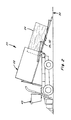
- FIG. 1 is a simplified side view of a module forming apparatus as part of a cotton harvesting vehicle having an on-board cotton module builder including a foldable unloading door arrangement in a harvesting configuration;
- FIG. 2 is another simplified side view of the module forming apparatus of the harvesting vehicle in an unloading configuration showing a cotton module moving from the module builder to a surface therebelow;
- FIG. 3 is yet another simplified side view of the module forming apparatus of the harvesting vehicle in the unloading configuration showing the cotton module as it reaches the surface;
- FIG. 4 is yet another simplified side view of the module forming apparatus of the harvesting vehicle in the unloading configuration after the cotton module has been unloaded;
- FIG. 5 is a simplified side view of a cotton module transport vehicle in the loading/unloading position
- FIG. 6 is a simplified schematic representation of a preferred embodiment of the system of the present invention.
- FIG. 7 is an example of a transport vehicle locating a desired cotton module for pickup
- FIG. 8 is an example of the transport vehicle locating a candidate cotton module that is not the desired cotton module
- FIG. 9 is a top view of a simplified schematic of a loading or unloading vehicle showing the determination of the location of the cotton module
- FIG. 10 is an exemplary Record that may be developed according to the invention.
- FIG. 11 is another simplified schematic representation of a preferred aspect of the invention.
- FIGS. 1 through 4 depict a self propelled cotton harvesting vehicle 20 including an on-board module forming apparatus, typically referred to as a cotton module builder 22 , of well-known construction and operation.
- a cotton module 24 is formed and held within module builder 22 until vehicle 20 is in position to unload.
- an unloading door 26 unfolds to form a ramp 32 as cotton module builder 22 is tilted to provide a continuous level surface for unloading cotton module 24 from module builder 22 to a surface 30 , in this case, the ground.
- Transport vehicle 28 includes a deployable ramp 34 for loading and unloading cotton module 24 between surface 30 and a holding structure 35 thereof.
- Cotton module 24 is moved along ramp 32 , 34 by a suitable driver system 76 which may include one or more independently controllable powered drag chains 78 , belts, rollers, or the like.
- a bale or cotton module 24 will have a length of about 16 feet, a width of about 8 feet and a height also of about 8 feet, or 500 ⁇ 250 ⁇ 250 cm.
- the invention is contemplated for use with harvesting vehicles and other machinery for harvesting and/or picking up or transporting any of a wide variety of plant material and biomass, and therefore is not limited to cotton, or transporters configured for loading modules from the ground, and can thus also include, for example, transporters configured for receiving a module directly from a harvesting vehicle or another transport vehicle.
- a system 36 and method for determining a location of an unloaded cotton module and locating a desired cotton module includes a communication network 58 configured and operable to communicate information between harvesting vehicle 20 and transport vehicle 28 or between a central location (not shown) and harvesting vehicle 20 and transport vehicle 28 .
- System 36 also includes a sensing system 40 associated with harvesting vehicle 20 and/or transport vehicle 28 for determining positions or progress of cotton module 24 relative to ramp 32 , 34 during loading and/or unloading. During an unloading operation, sensing system 40 provides an indicator when cotton module 24 is stationary on surface 30 or a location in predetermined relation thereto.
- sensing system 40 may provide the indicator when a first end 23 of cotton module 24 reaches and is stationary on surface 30 , or when a second end 25 of cotton module 24 has left ramp 32 , 34 , or both. ( FIG. 3 )
- sensing system 40 provides an indicator when the loading structure or ramp 34 has reached a loading position for cotton module 24 or a location in predetermined relation thereto.
- sensing system 40 may include sensors 80 that sense force or torque exerted on one or more drag chains 78 of driver system 76 . Changes in the force or torque may be monitored to determine the location of cotton module 24 along ramp 32 , 34 , or the departure of module 24 therefrom.
- a sensor 82 such as a load sensor, contact sensor, radar, sonic or other device that can sense presence and absence of module 24 from the end of ramp 32 , 34 .
- an optical sensor 84 may be monitored to determine when cotton module 24 passes a point on ramp 32 , 34 or when ramp 34 is in close proximity to cotton module 24 . (See FIGS. 4-5 .)
- Other well known sensing arrangements may be used to configure sensing system 40 for operation to provide an indicator when cotton module 24 and ramp 32 , 34 have reached a predetermined relationship therebetween, e.g., the module has left the ramp and is therefore stationary and is not being dragged, or otherwise still moving with the harvesting or transport vehicle.
- Communication network 58 includes at least one controller 60 and facilitates communication between sensing system 40 , a location system 42 , and a heading system 44 . Communication network 58 may also send and receive information regarding unloading and loading cotton modules and locations thereof through a user interface 48 associated with harvesting vehicle 20 , transport vehicle 28 , and the central location (not shown).
- Location system 42 is configured and operable to receive information, such as global positioning system (GPS) information identifying a location of an antenna or a receiver 43 of vehicle 20 , 28 .
- GPS global positioning system
- a heading system 44 receives the GPS information and determines or approximates a heading of vehicle 20 , 28 based thereon.
- controller 60 is configured and operable for automatically determining a location of unloaded cotton module 24 as a function of the location of receiver 43 of vehicle 20 , 28 and the heading thereof when sensing system 40 has sensed and indicated that cotton module 24 has reached surface 30 or the location in predetermined relation thereto.
- the location of cotton module 24 comprises a location of a predetermined reference point of module 24 and the heading of harvesting or transport vehicle 20 , 28 .
- point A is determined to be the location of unloaded cotton module 24 .
- torque or force levels exerted on drag chain or chains 78 , or exerted against ramp 32 , 34 , via an appropriate load sensor or sensors 80 , and/or optical sensors 84 , and/or contact switches or pads, radar, and sonic sensors 82 , can be used to determine the position or presence of module 24 at one or more locations on ramp 32 , 34 . If sensing system 40 provides an indicator when second end 25 of cotton module 24 has left ramp 32 , 34 and thus has reached surface 30 , point B is determined to be the stationary location of unloaded cotton module 24 .
- point C of cotton module 24 is determined to be the location of unloaded cotton module 24 .
- This location and the other location can also be determined from any one of the other locations if the pertinent dimension, e.g., length, of the module is known. It is important to point out that in each case, the heading of vehicle 20 , 28 , represented by an arrow at each point, is associated with the reference location.
- controller 60 is configured and operable to automatically determine whether a candidate cotton module 54 at a candidate location 56 is desired cotton module 50 as a function of the location of receiver 43 of transport vehicle 28 and the heading thereof when sensing system 40 has sensed and indicated that the structure or ramp 34 has reached candidate cotton module 54 or the location in predetermined relation thereto.
- controller 60 determines location 56 of candidate cotton module 54 as a function of the location of receiver 43 of loading or transport vehicle 28 when sensing system 40 has sensed and indicated that ramp 34 has reached candidate cotton module 54 or the location in predetermined relation thereto.
- Determination of the location of an unloaded cotton module 70 using the GPS position of receiver 43 of a harvesting or transport vehicle 72 at heading H is now explained with reference to FIG. 9 .
- the distance between receiver 43 and reference point D of cotton module 70 in meters is identified as DVM. If h is designated as the angle between heading H and true North, the latitude and longitude components of DVM may be expressed, in meters, as DVM_Y and DVM_X, respectively.
- DVM — Y cos( h ) ⁇ DVM
- DVM — X sin( h ) ⁇ DVM Converting meters to degrees, the latitude and longitude components of the distance between receiver 43 and reference point D may be expressed as DVM_Lat and DVM_Lon in degrees latitude and degrees longitude, respectively.
- DVM_Lat DVM_Y 2 * ⁇ * R * 360
- DVM_Lon DVM_X 2 * ⁇ * R * 360
- R is the radius of the Earth
- the location of module 70 M_Lat in degrees latitude and M_Lon in degrees longitude may be determined as follows:
- S is a multiplier based on whether vehicle 72 is in the Eastern or Western hemisphere.
- controller 60 determines that candidate cotton module 54 is desired cotton module 50 when candidate cotton module 54 has location 56 within a predetermined radius, or distance and direction, from location 52 of desired cotton module 50 .
- controller 60 may additionally use heading information to verify that candidate cotton module 54 is desired cotton module 50 .
- the desired heading may be compared to the candidate heading (if known), or the desired heading may be compared to the heading of transport vehicle 28 .
- the apparatus of ramp 34 of loading or transport vehicle 28 engages and moves desired cotton module 50 along ramp 34 from surface 30 to holding structure 35 in the loading or transport vehicle 28 .
- FIG. 5 illustrates the loading operation of desired cotton module 50 .
- communication network 58 includes a database 64 of stored records 62 associated with each cotton module 24 .
- record 62 includes at least information representative of unloading or loading vehicle identification, unloading or loading time, unloading or loading location, and the heading of the unloading or loading vehicle, respectively, for each time the unit of agricultural product is unloaded or loaded. Additional data stored in record 62 may preferably include information associated with the harvested cotton module including at least some of: seed type, timing and quantity of one or more chemicals or fertilizers applied, time of harvest, yield data at time of harvest, moisture content, harvesting location, identification of a processing facility, yield data at the processing facility, and quality of the processed cotton.
- controller 60 when controller 60 determines that candidate cotton module 54 is not desired cotton module 50 , as seen in FIG. 8 , the controller may access the records 62 in database 60 to identify candidate cotton module 54 as a function of the location thereof. Once identified, the decision can be made whether to pick up candidate cotton module 54 or continue efforts to locate desired cotton module 50 . As a result, using the present invention, if candidate module 54 is transported instead of desired module 50 , it is not an error, and data associated with candidate module 54 will be correctly stored in the record associated with module 54 . In addition, desired module 50 may be assigned to another transport vehicle.
- FIG. 11 illustrates another preferred embodiment of the invention in which the computational activities of system 36 have been redistributed.
- an on-board computer of harvesting vehicle 20 or transport vehicle 28 may include user interfaces 48 and may act as location system 42 and heading system 44 by processing GPS signals and determining the vehicle heading and location of cotton module 24 . It is also contemplated that these systems will have the capability to communicate wirelessly.
- the user can determine a location of a cotton module and locate a desired cotton module for transport. Additionally, the user may determine the identity of a candidate cotton module.
- the present invention is particularly advantageous because information associated with a crop at various phases of production, such as planting, growing, harvesting, transporting, processing, or classifying can be recorded, correlated, and analyzed for future decision making.
Abstract
Description
DVM — Y=cos(h)×DVM
DVM — X=sin(h)×DVM
Converting meters to degrees, the latitude and longitude components of the distance between
Claims (20)
Priority Applications (2)
| Application Number | Priority Date | Filing Date | Title |
|---|---|---|---|
| US13/845,880 US8942897B2 (en) | 2013-03-18 | 2013-03-18 | System and method for determining a location of an unloaded unit of agricultural product and locating a desired unit of agricultural product |
| PCT/US2014/010980 WO2014149152A1 (en) | 2013-03-18 | 2014-01-10 | System and method for determining a location of an unloaded unit of agricultural product and locating a desired unit of agricultural product |
Applications Claiming Priority (1)
| Application Number | Priority Date | Filing Date | Title |
|---|---|---|---|
| US13/845,880 US8942897B2 (en) | 2013-03-18 | 2013-03-18 | System and method for determining a location of an unloaded unit of agricultural product and locating a desired unit of agricultural product |
Publications (2)
| Publication Number | Publication Date |
|---|---|
| US20140278083A1 US20140278083A1 (en) | 2014-09-18 |
| US8942897B2 true US8942897B2 (en) | 2015-01-27 |
Family
ID=50064767
Family Applications (1)
| Application Number | Title | Priority Date | Filing Date |
|---|---|---|---|
| US13/845,880 Active US8942897B2 (en) | 2013-03-18 | 2013-03-18 | System and method for determining a location of an unloaded unit of agricultural product and locating a desired unit of agricultural product |
Country Status (2)
| Country | Link |
|---|---|
| US (1) | US8942897B2 (en) |
| WO (1) | WO2014149152A1 (en) |
Cited By (2)
| Publication number | Priority date | Publication date | Assignee | Title |
|---|---|---|---|---|
| US10266350B2 (en) | 2016-01-05 | 2019-04-23 | Walmart Apollo, Llc | Method and apparatus for unloading a cargo container |
| US20190332987A1 (en) * | 2015-08-17 | 2019-10-31 | Caterpillar Paving Products Inc. | Cold planer material transport management system |
Families Citing this family (3)
| Publication number | Priority date | Publication date | Assignee | Title |
|---|---|---|---|---|
| WO2015162703A1 (en) * | 2014-04-22 | 2015-10-29 | 富士通株式会社 | Farmwork results input support method, farmwork results input support program, and input support device |
| WO2018158630A1 (en) * | 2017-03-02 | 2018-09-07 | Agco Corporation | System and method for determining bale location and orientation |
| US20190265043A1 (en) * | 2018-02-28 | 2019-08-29 | Deere & Company | Agricultural crop package retrieval and tracking system and method |
Citations (30)
| Publication number | Priority date | Publication date | Assignee | Title |
|---|---|---|---|---|
| US5845229A (en) | 1996-10-28 | 1998-12-01 | Appropriate Systems | Method and apparatus for mapping crop quality |
| US6563417B1 (en) | 1998-10-26 | 2003-05-13 | Identec Solutions Inc. | Interrogation, monitoring and data exchange using RFID tags |
| US6614392B2 (en) | 2001-12-07 | 2003-09-02 | Delaware Capital Formation, Inc. | Combination RFID and GPS functionality on intelligent label |
| US20030228894A1 (en) * | 2002-06-11 | 2003-12-11 | Covington Michael J. | Unloader control for a combined cotton harvester and module builder and method of operation of the same |
| US6687616B1 (en) * | 2002-09-09 | 2004-02-03 | Pioneer Hi-Bred International, Inc. | Post-harvest non-containerized reporting system |
| US6691135B2 (en) | 2002-03-20 | 2004-02-10 | Deere & Company | Method and system for automated tracing of an agricultural product |
| US20050107934A1 (en) | 2003-11-18 | 2005-05-19 | Caterpillar Inc. | Work site tracking system and method |
| US7034683B2 (en) | 2000-11-06 | 2006-04-25 | Loran Technologies, Inc. | Electronic vehicle product and personnel monitoring |
| US20060086263A1 (en) * | 2004-06-09 | 2006-04-27 | Peter Degen | Bale set-down system |
| US7082740B2 (en) | 1999-10-05 | 2006-08-01 | Lely Research Holding A.G. A Swiss Limited Liability Co. | Device and method for wrapping bodies, especially bales of harvested agricultural produce |
| US7085777B2 (en) | 2002-03-20 | 2006-08-01 | Deere & Company | Method and system for tracing the identity of an agricultural product |
| US20060255951A1 (en) * | 2005-05-13 | 2006-11-16 | Ems Technologies, Inc., | Systems and methods for order-picking |
| US20060255948A1 (en) * | 2005-05-13 | 2006-11-16 | Ems Technologies, Inc. | Antenna for mobile wireless data collection system |
| US7250858B2 (en) | 2003-09-05 | 2007-07-31 | Sensitech, Inc. | Automated identification of anomalous conditions in supply chain processes |
| US20070181469A1 (en) | 2006-02-03 | 2007-08-09 | Stover Jimmy R | Technique for removing a cover from cylindrical modules |
| US20070282482A1 (en) * | 2002-08-19 | 2007-12-06 | Q-Track Corporation | Asset localization identification and movement system and method |
| US7313549B2 (en) | 2002-01-09 | 2007-12-25 | Hudson Frederick J | Remote materials management system |
| US7336181B2 (en) | 2003-02-21 | 2008-02-26 | Zachry Construction Corporation | Tagging and tracking system for assets and personnel of a commercial enterprise |
| US20080052876A1 (en) | 2006-02-03 | 2008-03-06 | Stover Jimmy R | Digesting cylindrical modules |
| US20080117023A1 (en) | 2006-11-21 | 2008-05-22 | Deere & Company | Agricultural information gathering system |
| US20080143482A1 (en) | 2006-12-18 | 2008-06-19 | Radiofy Llc, A California Limited Liability Company | RFID location systems and methods |
| US7394372B2 (en) | 2003-12-30 | 2008-07-01 | G2 Microsystems Pty. Ltd. | Method and apparatus for aggregating and communicating tracking information |
| US7397358B2 (en) | 2004-07-28 | 2008-07-08 | Aftercad Software Inc. | Method and system for location-centric information retrieval from wireless devices using RFID coding |
| US7415924B2 (en) | 2006-02-01 | 2008-08-26 | Roberts Jeffrey S | System and method for identifying bales of hay |
| US7434375B2 (en) | 2006-09-22 | 2008-10-14 | Deere & Company | Automated system for in-field storage, traceability and unloading of harvest products of harvested material from a harvesting machine |
| US20080252459A1 (en) | 2005-12-09 | 2008-10-16 | Butler Timothy P | Methods and systems of a multiple radio frequency network node rfid tag |
| US20080278328A1 (en) * | 2005-07-20 | 2008-11-13 | Rockwell Automation Technologies, Inc. | Mobile rfid reader with integrated location awareness for material tracking and management |
| US20100299029A1 (en) * | 2009-05-21 | 2010-11-25 | Fackler Robert L | Automatic control of a large bale loading apparatus |
| US20120319837A1 (en) | 2011-06-16 | 2012-12-20 | Foster Christopher A | System and method for identifying and locating a cotton module transported prior to marking |
| US20130006481A1 (en) | 2011-06-28 | 2013-01-03 | Foster Christopher A | Cotton module tracking system and method that eliminates cotton module marking |
-
2013
- 2013-03-18 US US13/845,880 patent/US8942897B2/en active Active
-
2014
- 2014-01-10 WO PCT/US2014/010980 patent/WO2014149152A1/en active Application Filing
Patent Citations (32)
| Publication number | Priority date | Publication date | Assignee | Title |
|---|---|---|---|---|
| US5845229A (en) | 1996-10-28 | 1998-12-01 | Appropriate Systems | Method and apparatus for mapping crop quality |
| US6563417B1 (en) | 1998-10-26 | 2003-05-13 | Identec Solutions Inc. | Interrogation, monitoring and data exchange using RFID tags |
| US7082740B2 (en) | 1999-10-05 | 2006-08-01 | Lely Research Holding A.G. A Swiss Limited Liability Co. | Device and method for wrapping bodies, especially bales of harvested agricultural produce |
| US7034683B2 (en) | 2000-11-06 | 2006-04-25 | Loran Technologies, Inc. | Electronic vehicle product and personnel monitoring |
| US6614392B2 (en) | 2001-12-07 | 2003-09-02 | Delaware Capital Formation, Inc. | Combination RFID and GPS functionality on intelligent label |
| US7313549B2 (en) | 2002-01-09 | 2007-12-25 | Hudson Frederick J | Remote materials management system |
| US7756719B2 (en) * | 2002-03-20 | 2010-07-13 | Deere & Company | Method and system for tracing the identity of an agricultural product using data handoff |
| US6691135B2 (en) | 2002-03-20 | 2004-02-10 | Deere & Company | Method and system for automated tracing of an agricultural product |
| US7085777B2 (en) | 2002-03-20 | 2006-08-01 | Deere & Company | Method and system for tracing the identity of an agricultural product |
| US20030228894A1 (en) * | 2002-06-11 | 2003-12-11 | Covington Michael J. | Unloader control for a combined cotton harvester and module builder and method of operation of the same |
| US20070282482A1 (en) * | 2002-08-19 | 2007-12-06 | Q-Track Corporation | Asset localization identification and movement system and method |
| US6687616B1 (en) * | 2002-09-09 | 2004-02-03 | Pioneer Hi-Bred International, Inc. | Post-harvest non-containerized reporting system |
| US7336181B2 (en) | 2003-02-21 | 2008-02-26 | Zachry Construction Corporation | Tagging and tracking system for assets and personnel of a commercial enterprise |
| US7250858B2 (en) | 2003-09-05 | 2007-07-31 | Sensitech, Inc. | Automated identification of anomalous conditions in supply chain processes |
| US20050107934A1 (en) | 2003-11-18 | 2005-05-19 | Caterpillar Inc. | Work site tracking system and method |
| US7394372B2 (en) | 2003-12-30 | 2008-07-01 | G2 Microsystems Pty. Ltd. | Method and apparatus for aggregating and communicating tracking information |
| US20060086263A1 (en) * | 2004-06-09 | 2006-04-27 | Peter Degen | Bale set-down system |
| US7397358B2 (en) | 2004-07-28 | 2008-07-08 | Aftercad Software Inc. | Method and system for location-centric information retrieval from wireless devices using RFID coding |
| US20060255951A1 (en) * | 2005-05-13 | 2006-11-16 | Ems Technologies, Inc., | Systems and methods for order-picking |
| US20060255948A1 (en) * | 2005-05-13 | 2006-11-16 | Ems Technologies, Inc. | Antenna for mobile wireless data collection system |
| US7932827B2 (en) * | 2005-07-20 | 2011-04-26 | Rockwell Automation Technologies, Inc. | Mobile RFID reader with integrated location awareness for material tracking and management |
| US20080278328A1 (en) * | 2005-07-20 | 2008-11-13 | Rockwell Automation Technologies, Inc. | Mobile rfid reader with integrated location awareness for material tracking and management |
| US20080252459A1 (en) | 2005-12-09 | 2008-10-16 | Butler Timothy P | Methods and systems of a multiple radio frequency network node rfid tag |
| US7415924B2 (en) | 2006-02-01 | 2008-08-26 | Roberts Jeffrey S | System and method for identifying bales of hay |
| US20070181469A1 (en) | 2006-02-03 | 2007-08-09 | Stover Jimmy R | Technique for removing a cover from cylindrical modules |
| US20080052876A1 (en) | 2006-02-03 | 2008-03-06 | Stover Jimmy R | Digesting cylindrical modules |
| US7434375B2 (en) | 2006-09-22 | 2008-10-14 | Deere & Company | Automated system for in-field storage, traceability and unloading of harvest products of harvested material from a harvesting machine |
| US20080117023A1 (en) | 2006-11-21 | 2008-05-22 | Deere & Company | Agricultural information gathering system |
| US20080143482A1 (en) | 2006-12-18 | 2008-06-19 | Radiofy Llc, A California Limited Liability Company | RFID location systems and methods |
| US20100299029A1 (en) * | 2009-05-21 | 2010-11-25 | Fackler Robert L | Automatic control of a large bale loading apparatus |
| US20120319837A1 (en) | 2011-06-16 | 2012-12-20 | Foster Christopher A | System and method for identifying and locating a cotton module transported prior to marking |
| US20130006481A1 (en) | 2011-06-28 | 2013-01-03 | Foster Christopher A | Cotton module tracking system and method that eliminates cotton module marking |
Non-Patent Citations (1)
| Title |
|---|
| PCT/US2014/010980, PCT International Search Report and Written Opinion dated Apr. 24, 2014. |
Cited By (3)
| Publication number | Priority date | Publication date | Assignee | Title |
|---|---|---|---|---|
| US20190332987A1 (en) * | 2015-08-17 | 2019-10-31 | Caterpillar Paving Products Inc. | Cold planer material transport management system |
| US10949786B2 (en) * | 2015-08-17 | 2021-03-16 | Caterpillar Paving Products Inc. | Cold planer material transport management system |
| US10266350B2 (en) | 2016-01-05 | 2019-04-23 | Walmart Apollo, Llc | Method and apparatus for unloading a cargo container |
Also Published As
| Publication number | Publication date |
|---|---|
| US20140278083A1 (en) | 2014-09-18 |
| WO2014149152A1 (en) | 2014-09-25 |
Similar Documents
| Publication | Publication Date | Title |
|---|---|---|
| US8942897B2 (en) | System and method for determining a location of an unloaded unit of agricultural product and locating a desired unit of agricultural product | |
| US9880559B2 (en) | Method and arrangement for monitoring the collection of plant material | |
| US7996134B2 (en) | System and method for identifying individual loads of chopped forage in storage | |
| Ampatzidis et al. | Field experiments for evaluating the incorporation of RFID and barcode registration and digital weighing technologies in manual fruit harvesting | |
| Ampatzidis et al. | A yield mapping system for hand-harvested fruits based on RFID and GPS location technologies: field testing | |
| US8407157B2 (en) | Locating harvested material within a work area | |
| US5845229A (en) | Method and apparatus for mapping crop quality | |
| US8706341B2 (en) | Method of detecting a structure in a field, a method of steering an agricultural vehicle and an agricultural vehicle | |
| US6687616B1 (en) | Post-harvest non-containerized reporting system | |
| US8452496B2 (en) | Cotton module tracking system and method that eliminates cotton module marking | |
| CN109195442A (en) | crop management system | |
| US8531300B2 (en) | System and method for tracking a cotton module | |
| US11268815B2 (en) | System and method of bale collection | |
| Whitney et al. | A DGPS yield monitoring system for Florida citrus | |
| EP2960832B1 (en) | Monitoring seed condition using wireless technology | |
| US20180252531A1 (en) | System and method of bale collection | |
| Rosa et al. | Design and evaluation of a yield monitoring system for pistachios | |
| US11280614B2 (en) | System and method of bale collection | |
| US20180252530A1 (en) | System and method of bale collection | |
| Ampatzidis et al. | A yield mapping system for hand-harvested fruits based on RFID and GPS location technologies | |
| Wang et al. | Round modules: update on handling logistics and cover damage | |
| Bagmanov et al. | The Program Complex of Operational Monitoring of Agricultural Machinery Work with the Use of High-Precision Positioning Systems | |
| Billingsley | Innovative mechatronic technologies in horticultural systems |
Legal Events
| Date | Code | Title | Description |
|---|---|---|---|
| AS | Assignment |
Owner name: CNH AMERICA LLC, PENNSYLVANIA Free format text: ASSIGNMENT OF ASSIGNORS INTEREST;ASSIGNORS:FOSTER, CHRISTOPHER A.;RINGWALD, JUSTIN R.;SIGNING DATES FROM 20130311 TO 20130318;REEL/FRAME:030032/0762 |
|
| AS | Assignment |
Owner name: CNH INDUSTRIAL AMERICA LLC, PENNSYLVANIA Free format text: CHANGE OF NAME;ASSIGNOR:CNH AMERICA LLC;REEL/FRAME:032996/0560 Effective date: 20140301 |
|
| STCF | Information on status: patent grant |
Free format text: PATENTED CASE |
|
| AS | Assignment |
Owner name: BLUE LEAF I.P., INC.,, DELAWARE Free format text: ASSIGNMENT OF ASSIGNORS INTEREST;ASSIGNOR:CNH INDUSTRIAL AMERICA LLC;REEL/FRAME:035641/0250 Effective date: 20150205 |
|
| MAFP | Maintenance fee payment |
Free format text: PAYMENT OF MAINTENANCE FEE, 4TH YEAR, LARGE ENTITY (ORIGINAL EVENT CODE: M1551) Year of fee payment: 4 |
|
| MAFP | Maintenance fee payment |
Free format text: PAYMENT OF MAINTENANCE FEE, 8TH YEAR, LARGE ENTITY (ORIGINAL EVENT CODE: M1552); ENTITY STATUS OF PATENT OWNER: LARGE ENTITY Year of fee payment: 8 |